Dreaming of a beach home on 30A, but unsure what the CCCL means for your build or renovation plans? You are not alone. Florida’s Coastal Construction Control Line can shape where and how you build along Walton County’s shoreline. In this guide, you will learn what the CCCL is, how it affects properties on 30A, and the steps to confirm feasibility before you buy. Let’s dive in.
What the CCCL is
The Coastal Construction Control Line is a state-established regulatory line along Florida’s beaches that helps protect dunes, beaches, and public access. It is not a property boundary. Instead, it overlays parcels and adds state permitting requirements for construction or repair work seaward of the line.
The CCCL program is administered by the Florida Department of Environmental Protection under Florida’s beach and shore preservation laws. Local permits from Walton County still apply, so projects often need both state and county approvals.
How the line is set and updated
FDEP establishes the CCCL using coastal surveys, beach profiles, and historical imagery. As beaches erode or are nourished, the line can be reestablished. Over time, a parcel’s status can change as conditions shift, which is why current maps and surveys are essential.
How it differs from other coastal lines
- CCCL vs. Mean High Water: Mean High Water is a tidal datum tied to some property limits. The CCCL is a regulatory control line that affects construction.
- CCCL vs. local setbacks: Walton County has its own coastal building setbacks and dune protection rules. These can be different from the CCCL and may be more restrictive.
- CCCL vs. erosion control or armoring rules: Other programs govern seawalls, nourishment, and erosion control. They interact with, but are not the same as, the CCCL.
What it means for 30A buyers
If any part of a proposed footprint falls seaward of the CCCL, state authorization is required. In many cases, new primary homes are not authorized seaward of the line. Parcels that are landward of the CCCL generally have a clearer path, but county setbacks, dune protection, flood elevations, and environmental constraints still influence design and placement.
Many gulf-front homes were built before modern CCCL rules. These nonconforming structures can typically remain, but expansions and substantial improvements face limits and may require mitigation or relocation. Review historic permits and approvals to understand what is allowed.
Beach nourishment or chronic erosion can shift regulatory conditions over time. A line reestablished farther seaward might open possibilities, while a landward reestablishment can add new limits. Treat the CCCL as dynamic, not fixed.
Lake-adjacent parcels are usually outside CCCL jurisdiction because the line applies to Atlantic and Gulf beaches and associated dunes. That said, other state or local rules can apply to lakes, wetlands, and buffers. If a lake connects to tidal waters or is part of the coastal system, higher oversight may apply. Confirm on a case-by-case basis.
Permits, studies, timelines, and costs
Projects seaward of the CCCL are reviewed by FDEP. Walton County also issues building and zoning approvals, and other agencies can be involved for wetlands, navigable waters, or protected species.
Common permit triggers include new primary structures seaward of the line, additions that move seaward, certain repairs after storm damage, and dune alterations or beach access structures. Expect careful scrutiny of any work that affects dunes or native vegetation.
Typical documentation includes a boundary and topographic survey, a site plan showing the CCCL, Mean High Water, and contours, coastal engineering cross-sections, dune and vegetation surveys, and historic permit records for nonconforming homes.
Plan for a multi-month review timeline. Simple cases may resolve in a few months, while complex or contested applications can take longer. Professional fees for surveys, engineering, and environmental consultants vary by scope. Application fees and mitigation, along with elevation and insurance requirements, should be built into your budget.
30A and Walton County specifics
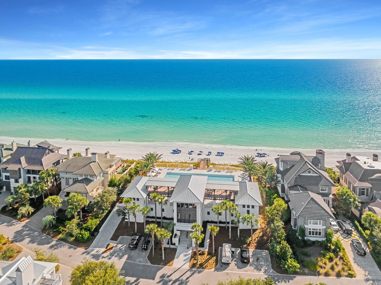
Along 30A, including Dune Allen Beach, you will find a mix of long-established gulf-front homes, newer builds behind dunes, and parcels shaped by erosion and periodic nourishment. Recent or planned nourishment can influence profiles and may lead to a reestablished line in the future. Always verify current conditions for your specific frontage.
Walton County enforces dune protection, coastal setbacks, and vegetation rules that complement state CCCL standards. Some stretches have seasonal restrictions for sea turtle nesting or protected habitats, which can affect timing and methods for construction or dune work. County permitting staff, GIS resources, and local coastal engineers are valuable starting points.
Due-diligence checklist for 30A buyers
Use this early in your process to avoid surprises and protect your timeline.
- Pull current CCCL maps and overlays
- Check the latest FDEP and Walton County GIS layers to see if any portion of the parcel is seaward of the CCCL.
- Order a certified boundary and topo survey
- Ensure the survey shows property lines, Mean High Water, dune features, elevations, and the CCCL relative to potential footprints.
- Request an FDEP determination or pre-application review
- Ask FDEP to confirm jurisdiction and offer preliminary guidance on your plans.
- Review historic permits and approvals
- Gather past CCCL permits, county variances, and any coastal authorizations that could affect rebuilds, repairs, or additions.
- Engage a coastal engineer early
- Have an engineer produce cross-sections and advise on feasibility, setbacks, and likely permit conditions before you finalize a design.
- Confirm local rules and HOA covenants
- Walton County codes and HOA guidelines may be more restrictive than state rules, especially on dune work, vegetation, and access.
- Check FEMA flood zones and elevation requirements
- CCCL jurisdiction is separate from flood rules. Both matter for design, elevation, and insurance.
- Ask targeted questions before you offer
- Is any part of the lot seaward of the CCCL?
- Were CCCL or coastal permits ever issued, and are there open enforcement items?
- If the structure is nonconforming, what are the limits on repairs or expansion?
- Has the shoreline been nourished recently, and could the line shift?
- Build time and cost buffers
- Plan for months of review, plus professional fees and possible mitigation.
Smart strategies for lot selection
- Favor landward parcels when possible. Being landward of the CCCL improves the odds of approval, though local rules still apply.
- Right-size the footprint. Compact, elevated designs and sensitive siting tend to review more smoothly than large, seaward-pushing plans.
- Preserve dunes and vegetation. Protecting native systems is central to approval and coastal resilience.
- Sequence your team. Engage surveyors, engineers, and your builder early so design and permitting move in step.
- Monitor shoreline projects. Stay current on nourishment schedules and any pending CCCL reestablishment that could change your parcel’s status.
Partner with a local expert
If you are weighing a gulf-front buy or a buildable lot behind the dunes, early guidance saves time and money. Our team pairs deep 30A experience with concierge service to help you understand feasibility, assemble the right consultants, and keep your goals in view from offer to closing. For tailored insight on a specific property or stretch of beach, connect with Randy Carroll.
FAQs
What is Florida’s CCCL and why it matters on 30A?
- It is a state regulatory line that adds strict controls on construction seaward of it to protect dunes and beaches, which directly affects buildability along 30A.
How do you check a 30A property’s CCCL status?
- Review the latest FDEP and Walton County GIS maps, obtain a certified survey showing the line, and request a formal FDEP determination if needed.
Can you build a new primary home seaward of the CCCL on 30A?
- Generally no; new primary residences seaward of the line are highly restricted and require state authorization that is rarely granted.
Can you rebuild a storm-damaged home that is seaward of the line?
- Possibly, but it is case-specific; limits on repairs and substantial improvements apply, and historic permit records are important.
Does the CCCL apply to Walton County’s coastal dune lakes?
- The CCCL governs Gulf beaches and dunes; lake properties often fall under other state and local environmental rules, confirmed case by case.
How long does a CCCL authorization usually take?
- Expect a multi-month process; straightforward projects can move faster, while complex or contested cases take longer.
What costs should you expect for CCCL-related due diligence?
- Budget for surveys, coastal engineering reports, permit application fees, possible mitigation, and added construction and elevation requirements.